For current news content, please visit EarthScope.org.

Home

Filter

Showing 97 - 108 of 171 posts

21 Dec 2018

Subduction Below Extreme Sedimentation

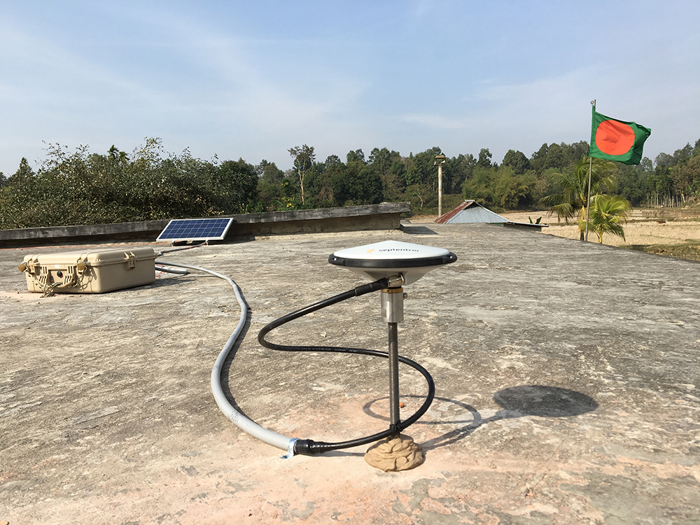
Subduction Below Extreme Sedimentation: Multidisciplinary Transect from the Ganges-Brahmaputra Delta to the IndoBurma Backarc Overview UNAVCO has been supporting NSF-funded GPS observations in the Ganges-Brahmaputa Delta of Bangladesh since 2003. GPS position estimates collected from the deployed instruments have provided evidence that there is 13-17 mm shortening across this region per year. Initially, it was … Continued

30 Nov 2018

Response to the 2018 Eruption of Sierra Negra Volcano

Project Overview The Sierra Negra volcano on Isabella Island in the Galápagos Archipelago erupted spectacularly in 2005 with lava fountains reaching more than 200 meters high, and a gas/ash plume reaching 15 km altitude. Various types of data collected before, during and after that eruption gave earth scientists a better understanding of volcanic processes, some … Continued

28 Aug 2018

Upgrade to a Global Network

Upgrade to a Global Network: Maintaining the NASA GGN Overview UNAVCO, in collaboration with the NASA Jet Propulsion Laboratory (JPL), is responsible for the operations and maintenance of the 57 permanent GNSS stations that make up a large portion of the NASA Global GNSS Network (GGN) (Figure 1). The GGN is NASA’s contribution to the … Continued

23 May 2018

cGPS Used to Study Slow Slip Landslide

Project Overview From February 12th through 16th, UNAVCO’s Dylan Schmeelk and John Galetzka joined UC Santa Cruz professor of Earth and Planetary Sciences Noah Finnegan (PI) and his graduate students Alex Nereson and Colleen Murphy in Oak Ridge in the mountains just east of Milpitas, CA to upgrade continuous GPS (cGPS) monitoring of the slow … Continued

22 May 2018

Maintenance of Continuous GPS Stations in Panama

Project Overview Over two weeks in April 2018, PhD student Gorki Ruiz from The Pennsylvania State University (PSU), Omar Espinoza (Sub-Director General), Javier Cornejo (Departamento de Geodesia) and Demetrio Garcia (Departmento de Cartografia) from Instituto Geográfico Nacional “Tommy Guardia” (IGNTG) / Autoridad Nacional de Administración de Tierras (ANATI), and Dylan Schmeelk from UNAVCO traveled throughout … Continued

2 Mar 2018

NASA Global Geodetic Network Station Upgrade

Overview The NASA Jet Propulsion Laboratory (JPL) operates a global network of over 60 permanent GNSS stations called the Global Geodetic Network (GGN). UNAVCO offers support to the GGN by providing data flow monitoring, troubleshooting, station installation and maintenance, and engineering services to help improve the capabilities and performance of station infrastructure. In March of … Continued

12 Feb 2018

The NASA Space Geodesy Project – An Update

Overview NASA’s Space Geodesy Project (SGP) was initiated in order to develop and maintain a global network of next-generation space geodetic observing instruments. Core sites around the globe will use three or four of the primary space-geodetic techniques: Very Long Baseline Interferometry (VLBI), Satellite Laser Ranging (SLR), Doppler Orbitography by Radiopositioning Integrated on Satellite (DORIS), … Continued

11 Jul 2017

Episodic GPS Data Collection in Panama

Overview Over two and a half weeks in June 2017, graduate student Gorki Ruiz from The Pennsylvania State University (PSU), Omar Espinoza and Javier Cornejo from Instituto Geografico Nacional “Tommy Guardia” – Departamento de Geodesia, and Mike Fend from UNAVCO traveled throughout much of Panama to collect episodic GPS data (eGPS) and service previously installed … Continued

23 Jun 2017

UNAVCO UAS Completes Survey of Cryoconite Holes on Antarctic Glacier

Overview Cryoconite holes are pockets of life completely encased in otherwise barren glacial ice. These features are formed from when dust blown onto a glacier melts a small, largely isolated hole that can function as its own tiny ecosystem. This dust can contain microorganisms such as bacteria, algae, or microscopic animals. The microorganisms within the … Continued

30 Mar 2017

TLS of Topographic Roughness and Sediment on Hillslopes

Overview Terrestrial laser scanning (TLS) was used in project support of researchers from the University of Oregon refining sediment transport models in steep terrain. TLS yielded measurement densities of greater than one point per centimeter, enabling researchers to image tree throws, or the cavities left behind by a tree’s roots when the tree is upended. … Continued

17 Feb 2017

P278 – Steel Was All That Remained

Project Overview In August and September of 2016, the Chimney Fire burned through 46,000 acres of San Luis Obispo County near the central California coast. In addition to destroying dozens of homes and structures, the fire also swept over P278 Clarke Mountain, a GNSS station located on a high ridge within the burn zone. While … Continued

17 Feb 2017

Designing a Power System for Radars in Greenland

Project Overview The UNAVCO polar services team developed a power system for three radar systems in Greenland for the summer of 2016. The radar was to scan, multiple times a day, the calving front of Jakobshavn Glacier on the west coast of Greenland, near Ilulissat, and Helheim Glacier on the east coast of Greenland, near … Continued