For current news content, please visit EarthScope.org.

Home

Filter

Showing 133 - 144 of 171 posts

10 Apr 2014

Connecting museum visitors to geohazard science and GPS technology

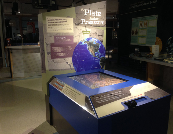
Project Overview Monitoring a Shifting Earth is a new science exhibit on display at Oregon State University’s Hatfield Marine Science Visitor Center (HMSC), a Sea Grant Institution in Newport, Oregon. UNAVCO Science Education Specialist Shelley Olds worked with Bob Butler from the University of Portland and Bob Lillie and Nancee Hunter from Oregon State University to … Continued

14 Mar 2014

UNAVCO installs COCONet cGPS sites CN04 and CN47 in Saint Lucia

Overview Determining how the Caribbean plate moves with respect to the neighboring North America and South America plates has been a major challenge. Geologic plate motion models using seafloor magnetic anomaly rates, transform fault azimuths, and slip vectors are challenging due to sparse data. The only rates come from the Cayman Spreading Center, and seismicity … Continued

12 Mar 2014

Maintaining POLENET Sites from the South Pole

Overview POLENET in Antarctica is a multidisciplinary NSF-funded project examining the geology and geophysics of the Antarctic continent. The associated network of autonomous GPS and seismic equipment spans much of the continent, enabling researchers to explore the geological history of the Trans-Antarctic Mountains, the structure of the Antarctic lithosphere, and the dynamics of continental ice … Continued

10 Mar 2014

Seals, a Lava Lake, and Subglacial Microbes: 2013-2014 Antarctic TLS Highlights, Part 1

Scanning Weddell Seals PI: Robert Garrott, Montana State UniversityEvent: B-009 UNAVCO supported ongoing research of Weddell seal populations of McMurdo Sound with TLS data and engineering in November 2013. Two UNAVCO TLS instruments were used in unison to instantaneously collect a high-resolution scan of Weddell seals lying on sea ice. A novel methodology is being … Continued

14 Feb 2014

UNAVCO installs COCONet cGPS sites CN13 and CN14 in the Bahamas

Project Overview Determining how the Caribbean plate moves with respect to the neighboring North America and South America plates has been a major challenge. Geologic plate motion models using seafloor magnetic anomaly rates, transform fault azimuths, and slip vectors are challenging due to sparse data. The only rates come from the Cayman Spreading Center, and … Continued

10 Feb 2014

UNAVCO installs COCONet cGPS site CN05 in the Dominican Republic

Overview Determining how the Caribbean plate moves with respect to the neighboring North America and South America plates has been a major challenge. Geologic plate motion models using seafloor magnetic anomaly rates, transform fault azimuths, and slip vectors are challenging due to sparse data. The only rates come from the Cayman Spreading Center, and seismicity … Continued

30 Jan 2014

Tracking Subsidence in Houston

Overview UNAVCO is supporting the design and construction of more than 40 new permanent GPS stations in the greater Houston metropolitan area. This network, called HoustonNET, will provide data for a study undertaken by Dr. Bob Wang from the University of Houston to measure ground subsidence in the region. In January of 2014, UNAVCO engineer … Continued

20 Nov 2013

Scanning vegetation and landforms in Arizona

Project Overview In April of 2013, UNAVCO supported the first half of a two-part terrestrial laser scanning (TLS) project undertaken by scientists at the University of Montana. The April survey took place on the Santa Maria River in arid northwestern Arizona. The second half will be conducted on the Bitterroot River in Montana in the … Continued

20 Nov 2013

Troubleshooting COCONet cGPS sites in Panama

Project Overview Determining how the Caribbean plate moves with respect to the neighboring North America and South America plates has been a major challenge. Geologic plate motion models using seafloor magnetic anomaly rates, transform fault azimuths, and slip vectors are challenging due to sparse data. The only rates come from the Cayman Spreading Center, and … Continued

20 Nov 2013

Scanning vegetation and landforms in Montana

Project Overview In August of 2013, UNAVCO supported the second half of a two-part terrestrial laser scanning (TLS) project undertaken by scientists at the University of Montana. The August survey took place on the Bitterroot River in Western Montana. The first half of the project was conducted on the Santa Maria River in Arizona in … Continued

20 Nov 2013

UNAVCO upgrades COCONet cGPS sites in Jamaica

Project Overview Determining how the Caribbean plate moves with respect to the neighboring North America and South America plates has been a major challenge. Geologic plate motion models using seafloor magnetic anomaly rates, transform fault azimuths, and slip vectors are challenging due to sparse data. The only rates come from the Cayman Spreading Center, and … Continued

20 Nov 2013

Hands-on Learning at the Hilton Creek Fault in California

Project Overview UNAVCO provided an engineer and TLS equipment to assist with the UC Santa Cruz field camp this past summer in the Eastern Sierra Nevada. Each year, geology undergraduates from the university stay at the Sierra Nevada Aquatics Research Lab (SNARL) for one week as part of their six-week-long field camp, dedicated to familiarizing … Continued