This page provides brief tutorials on GPS and 3D imaging, as well as geodesy education handouts suitable for the classroom and professional development workshops. You will also find Google Earth KMZs with embedded geodesy-related material and additional learning material from the UNAVCO community.
These tutorials are designed for students and the general public to introduce key concepts in the Global Positioning System (GPS), the United States component of the Global Navigation Satellite System (GNSS).
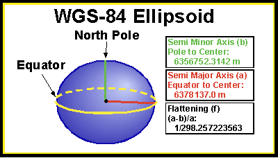
The Shape of Earth and Reference Ellipsoids
This tutorial was written by a UNAVCO Community Member
Learn about ellipsoids, reference ellipsoids, the advantages of using models in science, and how a GPS receiver determines elevation. This tutorial is suitable for both teachers and students.
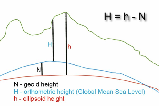
The Geoid and Receiver Measurements
This tutorial was written by a UNAVCO Community Member
In this tutorial, you will learn about the difference between the reference ellipsoid and the geoid, and how these concepts come together to tell us the true elevation about sea level.
GPS Basics
Tutorials from the UNAVCO GPS Spotlight
Learn about the basics of GPS and how scientists use it to study plate tectonics, earthquakes, volcanoes, and the water cycle.
More Tutorials from the Geodesy Community
Geodesy, Do you know where you are? - The Global Positioning System
A tutorial developed by the National Oceanic and Atmospheric Administration (NOAA)
Geospatial Lessons and Resources
COMET - University Corporation for Atmospheric Research (UCAR)
These tutorials were developed to explain lidar and 3D imaging techniques. For more tutorials on these topics, visit the OpenTopography tutorials page.
OpenTopography Tutorial: Downloading High Resolution Topographic Imagery for Google Earth
This video tutorial will walk through downloading KMZ files - containing images created from digital elevation models (DEM’s) - from OpenTopography.
Also available as a PDF.
OpenTopography Tutorial: Accessing and Downloading Global Topographic Data
This video will walk through discovering and downloading global topographic digital elevation model (DEM) data from OpenTopography, including ALOS World 3D and Shuttle Radar Topography Mission (SRTM) datasets.
The OpenTopography education and training resources related to high-resolution topography data. OpenLandform Catalog serves as a resource to explore geologic landforms in high resolution digital topography for teachers, students or any interested user.
These handouts and Google Earth KMZs are designed for use in classrooms, teacher materials, or professional development workshops.
Google Earth KMZs
Learn about Plate Tectonics Google Earth KMZ GPS velocity vectors, earthquake locations, volcano locations, plate boundaries, lidar, age of the ocean floor, and more! Version: December 2017.
Yellowstone National Park Google Earth KMZ Includes the Yellowstone National Park map, as well as learning activities about calderas, lidar, geysers, earthquakes, hydrothermal activity, and GPS. This KMZ has an associated learning module: Taking the Pulse of Yellowstone’s “Breathing” Volcano: Problem-Based Learning in America’s First National Park . Version: January 2018.
GPS Velocity Vectors Reference Key
Explore plate motion using high-precision GPS velocity vectors near your location. This handout provides step by step instructions to the UNAVCO Velocity Viewer. Version: September 2015 [pdf].
Place-Based Education
Handouts showing ground motions measured by high-precision GPS that are part of the EarthScope Plate Boundary Observatory and other networks. The maps are created using the interactive Velocity Viewer.
Ice Breaker: Getting to Know You
This activity is designed to introduce workshop participants and instructors to one another, to investigate some facts about plate tectonics, GPS, and earthquakes, and how they have affected people in the group. [pdf] [docx]
Worksheet: Incorporating data and activities into your teaching
A guided action plan to add workshop materials into your classes. Version: April 2015. [pdf] [docx]
Last modified: 2019-12-24 01:25:31 America/Denver