
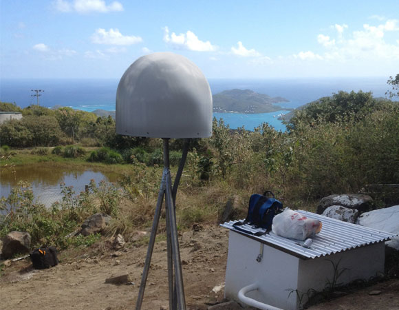
CN03: Virgin Gorda, British Virgin Islands. Photo by Mike Fend.
Project Overview
Puerto Rico and the northern Virgin Islands define the eastern terminus of the Greater Antilles, which extend eastward from offshore eastern Central America to the Lesser Antilles volcanic arc and mark the boundary between the Caribbean and North America plates. In Hispaniola, Puerto Rico, and the northern Virgin Islands, the Puerto Rico trench and the Muertos trough define the northern and southern limits of the plate boundary zone, respectively.
The Anegada Passage, which separates the British Virgin Islands and the island of Anguilla, is reported to be a “tectonic” boundary between the Lesser Antilles forearc block and the Puerto Rico-Virgin Islands block. A new continuous GPS site installed as part of the Continuously Operating Caribbean GPS Observational Network (COCONet) project will allow researchers to test kinematic and block models more rigorously and also potentially constrain elastic strain accumulation along the plate interface.
UNAVCO Connection
This GPS site has been constructed for the COCONet project on the highest peak of Virgin Gorda in the British Virgin Islands. This site not only has the standard geodetic monument, GPS receiver, and meteorological station to monitor plate and hurricane movement, but also includes a seismometer. Collaborating with Jasen Penn at the British Virgin Isands Department of Disaster Management and Jose Cancel at the University of Puerto Rico Mayaguez Campus allowed UNAVCO engineers to have invaluable help before, during, and after the installation. The ultimate owners and caretakers will be the Bristish Virgin Islands Department of Disaster Management after COCONet construction is completed. The network is currently halfway complete as of April 2013.
Significance
The COCONet project was funded by the National Science Foundation (NSF) with the aim of developing a large-scale geodetic and atmospheric infrastructure in the Caribbean that will form the backbone for a broad range of geoscience and atmospheric investigations and enable research on process-oriented science questions with direct relevance to geohazards. The Caribbean Plate is a unique opportunity to monitor movement, because most of the plate rests underwater. Prior to this endeavor there has been limited monitoring of the Caribbean Plate. Furthermore, each site is equipped with a weather station which records vital atmospheric data that is analyzed by our friends at the University Corporation for Atmospheric Research (UCAR) to monitor the movement of potentially deadly hurricanes.
Project Information
- Principal Investigators: COCONet
- UNAVCO Engineers: Mike Fend, Abe Morrison
- Date: February 2013
- Locations: CN03: Virgin Gorda, British Virgin Islands
- Funding Source: NSF, COCONet
- Map of Virgin Islands
Related Links
- COCONet
- Jansma, P.E., and G.S. Mattioli, G.S., 2005, GPS results from Puerto Rico and the Virgin Islands: Constraints on tectonic setting and rates of active faulting, in Mann, P., ed., Active tectonics and seismic hazards of Puerto Rico, the Virgin Islands, and offshore areas: Geological Society of America Special Paper 385, p. 13–30.
Written by:
- Mike Fend
- Posted: 2 May 2013
- Last updated: 15 July 2021
- Tags: COCONet, GPS/GNSS, project highlights
-

